|
This week I have done a lot of work on my personal project. We have finally finished applying for the permit and at the time of writing this I am waiting to hear back from some references to see if they can write a letter of recommendation for our collecting permit. This permit process involved a lot of writing that has occupied my time for the past couple of weeks. Because of this I have not had very much time to work on my digital art piece. hopefully I will be able to get out on Friday so that I can take a picture, process it, and print it. I do have a couple ideas for the art piece although, I think either a drone shot or a picture with half in the water and half out of the water shot of some buoyed boats in mission point park would make for a pretty cool picture. I am really excited to get back in the water because it has been a while because of all of the paperwork that I have been working on. I have always wondered how you can work one hundreds of pages of paperwork but after this process I can finally understand.
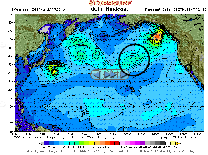
Unfortunately, this storm is heading for the south coast of Alaska and not southwest towards San Diego. You can tell which way the storm is heading by the little arrows inside the storm which represents wind direction. Another thing that contributes to storm direction is the wind direction of where the storm is headed. External winds can push the storm and change the course of the storm. We then find the coordinates of the storm and of San Diego. We can find the coordinates by using the numbers on the borders of the map. The storm's coordinates are approximately 40N, 15oE and San Diego's coordinates are approximately 35N, 120E. We can then calculate the distance between these two points. My first thought was to use trigonometry to find the distance but that is assuming that the earth is round (which it is not) so I used a great circle calculator which can be found here. This calculation take into account the curvature of the earth to tell us the actual distance between two points. In our case the storm would be 1456.112 nautical miles Using this calculation we can calculate the approximate time it will take to reach San Diego. The formula is Distance in nautical miles/Period*1.5=time in hours. The period is the time in between waves. We can find the period by matching the colors inside the storm to the horizontal bar below the image. In our case, the period would be 16. plugging in our values, we find that it will take 60.67 hours for the waves caused by the storm to reach San Diego.
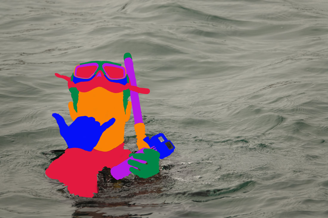 This is my digital art piece. I was very proud of this because I have never been very comfortable in art and I thought that this turned out very well. It also got printed out and is in the fishbowl now. I am very excited for this because it is the first photo of mine to be printed and hung at High Tech High. Below is some of my responses.
Significance I find that whenever I am near the ocean, I am having a good time. Some of my earliest experiences were going to the beach during the summer and bodyboarding all day tell we got so sunburned that we couldn’t bare it and would go home. While the beaches of San Diego might not be the most picturesque with clear water and white sands, I always find that when I am in the ocean, it’s an adventure. When I first saw this picture, I was a little disappointed by how dull the colors were. Everything in the photo was dull I I thought that it did not accurately depict my experience that day. For this reason, I decided to color the subject in bright colors to make my experience better represented by the picture. Perspective This is a picture taken by Evan Vavra of me snorkeling at Mission Point Park. Evan was standing on the jetty with the RX 10 taking pictures of Brian and I in the water. It was a cold dreary day in April. The visibility of the water was around seven feet so it was a relatively clear day and we saw many things in the water including stingrays, halibut, crab, and sea cucumber. The main goal of the day however, was to put the artificial reefs that my peers created out of clay into the bay. Some of the pictures that I took of the reefs are on the wall in the fishbowl. Evidence- Life is only how you think of it. What is a terrible thing for one person can make another persons day. I feel like in photography, this is especially true. A picture only conveys what the photographer wants it to convey. For example, a photographer may go to a war torn country that is of course very sad, but the pictures they take may not be sad by showing the power of human destruction, but hopeful by showing the power of human resilience. In this photo I was attempting to turn a rather dreary photo and make it vibrant and full of life. I did this by coloring the subject (myself) with bright and vibrant colors. Connection- As a native San Diegan, I feel a profound connection to the ocean. From going to the beach during summer days with my mom to paddle boarding with my dad, I have spent a significant amount of my childhood in the ocean. It is a privilege to live in San Diego for this reason. Many people go their whole life without living their city much less drive hundreds of miles to go to the beach. Because of this disconnect to the ocean, many problems that are facing oceans are not being discussed. By taking photos in and around the ocean, we can show the general population that the oceans can and need to be saved.
0 Comments
Leave a Reply. |
Semester AzulThis semester I am in Semester Azul which is a class with around 20 students of all high school grade levels. We are exploring the vast mysteries of the ocean learning about the ecosystems, climate, and human influence. I hope you enjoy my progression!. Archives
May 2019
Categories |
 RSS Feed
